Photogrammetric Analysis of Zapruder and Nix Movie Film
by
Paul H. Salamonowicz
INTRODUCTION AND BACKGROUND
In July 1978, the U.S. House of Representatives Select Committee on Assassinations (SCA) requested U.S. Geological Survey (USGS) assistance in their investigation of the assassination of President John F. Kennedy. The assistance involved photogrammetric analyses of movie film and several snapshots. The snapshots were of Lee Harvey Oswald in the backyard of his home in Dallas in 1963, and the movie films were taken during the assassination by two separate bystanders, named Zapruder and Nix. This report deals only with the analysis of the movie film and prints made from selected frames.
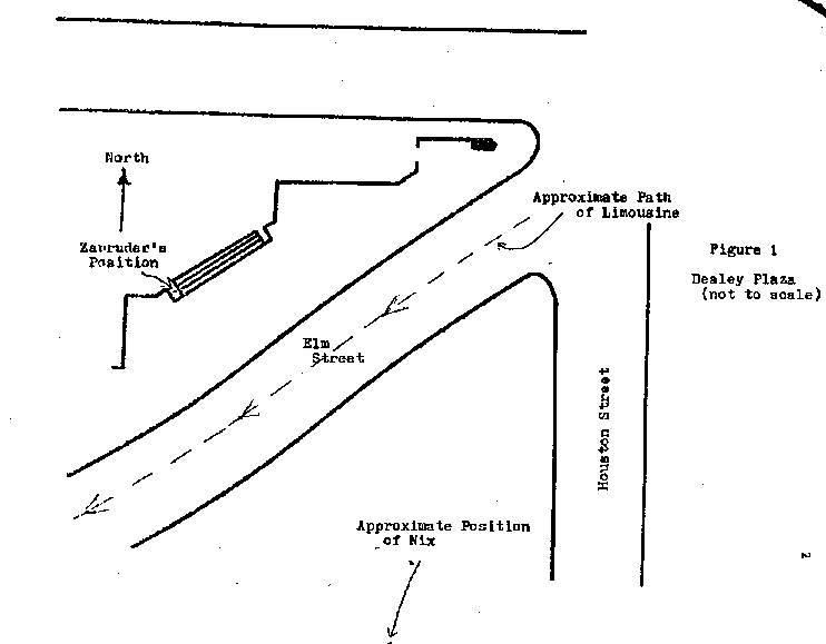
The photographic material delivered by the SCA included: (1) a 16 mm copy of the Zapruder film, (2) enlarged prints of selected frames of the Zapruder film, (3) prints of selected frames from the Nix film, and (4) a 1:120-scale map of the Dealey Plaza area. The movies were taken of the presidential limousine as it traveled southwesterly along Elm Street throtgh Dealey Plaza, Dallas, Texas. Figure 1 is a sketch of Dealey Plaza showing the route of the limousine and the locations of Zapruder and Nix. Zapruder's position is precise, but Nix's position is approximate.
2
3
The SCA requested that the position of the limousine be determined from frames 150, 190, 285, 313, and 413 of the Zapruder film. If for any reason one of these frames could not be used, the nearest suitable frame was to be substituted. The Nix prints were supplied as a supplement to the Zapruder film.
Once the limousine positions were determined, they were to be plotted on the map supplied by the SCA. It was determined that the most suitable frames nearest to those requested by the committee were the following: frames 151, 193, 272, and 410 from the Zapruder film, and the print from the Nix film that corresponded in time to Zapruder's frame 313. Initially, it was thought that it would be necessary to substitute Zapruder movie frame 173 for frame 150, and although this proved to be unnecessary, the position had been determined and was, therefore, plotted.
Mr. Everett L. Merritt, photogrammetric consultant to the SCA, acted as liaison between the committee and the USGS. The approach used in determining the limousine positions was devised by Dr. Atef Elassal, USGS, and is described in the following section.
4
DETERMINATION OF LIMOUSINE POSITIONS
Two methods were used in determining the limousine positions, the method used depending upon the amount of "ground control" available. An analytical approach (single photo orientation) was used for frames containing a sufficient number of images of objects whose ground positions were known. For those frames containing an insufficient number of these identifiable ground control points, a graphical approach was used. Regardless of the method, certain assumptions were made:
(1) Zapruder remained in the same general position during the filming sequence, (2) the principal point of both the Zapruder and Nix film was at the center of format of the photos as determined by the intersection of the diagonals from opposite corners, and (3) that the given design focal length (27 mm) of Zapruder's camera was the actual focal length.
Analytical Method
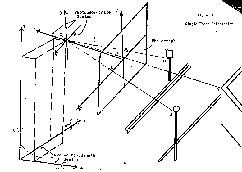
To determine the location of the limousine mathematically, GIANT, a reliable computer program, was used to first compute the angular orientation of the camera for each exposure and then using the camera somewhat as a sighting device to compute lines of sight to the front and rear of the limousine. The following data was used in the computations: the ground coordinates of control points used to determine camera orientations, the photocoordinates of these imaged points, the approximate focal length of the camera, the principal point of the photo, the photocoordinates of points on the limousine, and the ground
5
coordinates of the camera at the instant of exposure (perspective center of camera). Because the camera had a narrow field of view, errors in certain parameters, such as focal length, were not critical. The relationship between these parameters is illustrated in figures 2 and 4.
All ground-point coordinates used as input were obtained from measurements made with the Bendix Datagrid Digitizer on the map supplied by the committee. The photocoordinates were measured with a Kern MK2 monocomparator (Zapruder film) and the Bendix Datagrid Digitizer (Nix print). The focal length of the Zapruder camera was given, but because the copy of the Zapruder film was an enlargement of the original film, the focal length was computed as the original length multiplied by the ratio of the size of the enlarged film to the original frame size.
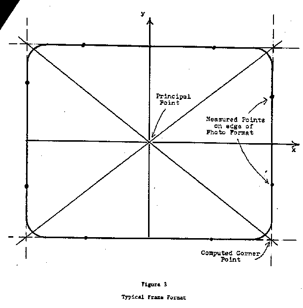
To convert comparator measurements to photocoordinates, two points along each of the four edges (fig. 3) were measured to define mathematically lines along the edges. Each pair of perpendicular lines were then intersected to obtain the photocoordinates of the frame corner. The intersection of the lines connecting diagonally opposite corners yielded the principal point (photo center) coordinates. Each of the measured photocoordinates of image points were then translated such that the principal point was the origin of the photocoordinate system.
6
7
8

9
The focal length of the Nix camera was not given. Based on measurements of a wall imaged during the Nix filming sequence, the focal length was estimated. Because the focal length was estimated directly from measurements on the enlarged print, it was unnecessary to compute an enlargement factor. Principal point coordinates and photocoordinates for the Nix print were determined by the same method used with Zapruder's film. Since Zapruder's position was known and did not change during the filming sequence, the coordinates of the exposure station (L) are the same for each frame and were measured on the map. Nix's position was not fixed and his exposure station (L) could only be estimated from the map. This information was input into USGS program GIANT, an analytical triangulation program which performed the single photo orientation in a rigorous adjustment by the method of least squares. This adjustment yielded a statistically most probable solution.
Figure 4 is a view of the oriented photograph. Using an assumed focal length and measured photocoordinates, the angles between the lines of sight originating at the perspective center (L) were computed. Hence, the angular relationships between points on the limousine (points D and E in fig. 4) and the control points (points A, B, and C in fig. 4) were computed. However, this information was not sufficient to locate the limousine absolutely, even though the true distance between points D and E in figure 4 was known from a scale drawing of the limousine.
10
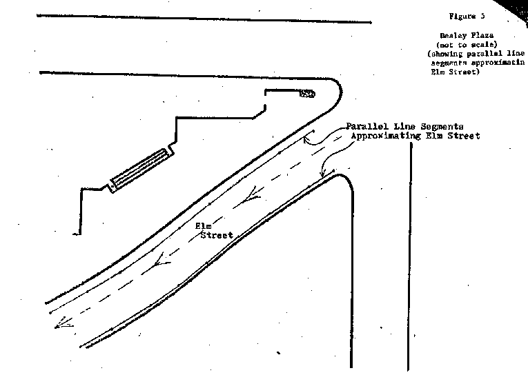
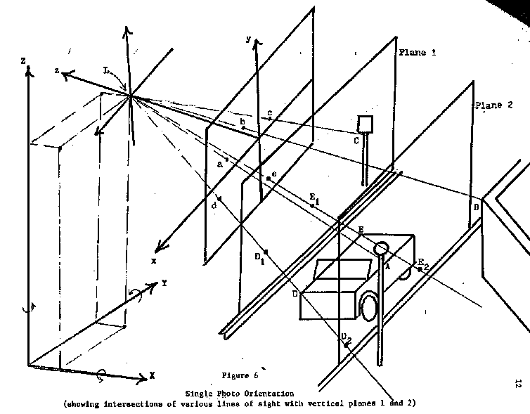
Because the limousine orientation was unknown, an infinite number of limousines, each at the correct scale, and each corresponding to image points d and e could have been located. If a third point along line segment DE had been known, the car could have been absolutely located. However, a third colinear point was not available so a reasonable assumption was made which allowed the limousine position to be determined with only 2 points: that the limousine traveled essentially parallel to the sides of the street. The gently curving sides of the street were approximated by short parallel line segments as shown in figure 5, and the limousine was assumed to be parallel to and between these line segments at each given instant. These parallel line segments were drawn on the original map and measured at the same time as the ground control. Each line segment defined the intersection of a vertical plane (for example, planes 1 and 2, fig. 6) and a horizontal plane (map). As can be seen in figure 6, the line from L to d passed through not only point D but also points D1 and D2, located in planes 1 and 2, respectively. Similarly, the line from L to e passed through points E, E1, and E2. The limousine projection onto plane 1 was too small because the plane was closer to the exposure station than the limousine actually was. The limousine projection onto plane 2 was too large because it was farther away from the exposure station than the limousine actually was. Because ground coordinates were computed for points D1, E1, D2, and E2, and the true length of line segment DE, parallel to planes 1 and 2, was known, the ground coordinates of points D and E were computed, and the car was
11
12
13
thus located. Once the ground coordinates of points D and E were computed, the map was placed on the digitizer (the instrument used to measure the ground control on the map) and the grid coordinates of the points on the limo were located and marked. It was then a simple matter to draw the limousine to scale with these points.
This procedure was used to locate the limousine positions from Zapruder frames 151, 173, and 193 and from the Nix frame corresponding to Zapruder frame 313.
Graphical Method
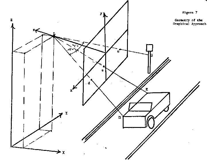
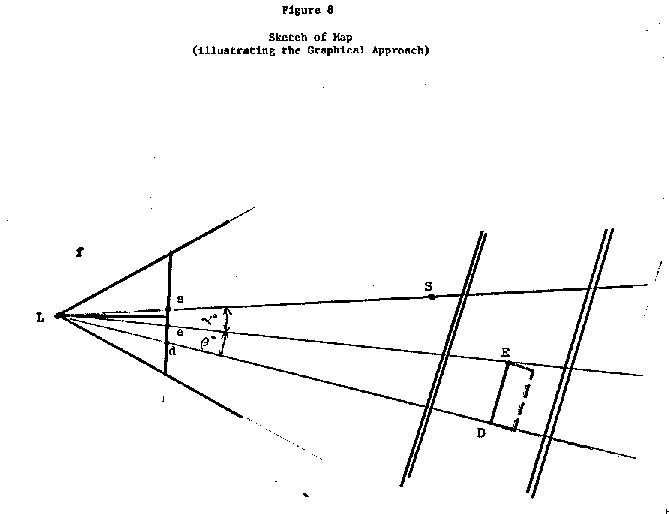
If only one object with known ground coordinates appeared in the photo, a graphical approach was used. Figure 7 illustrates the geometry involved in this graphical approach. L was the camera position (Zapruder). The photocoordinates of the street sign (S) and limousine points D and E were measured with the comparator. The principal point was determined by the same method described for the analytical approach, and, once again, became the origin of the photocoordinate system. Figure 8 shows a sketch of the map. Since the map positions of points L and S were known, the line from L to S was drawn with a straight edge. Because of the location of the points in the photo and the nearly horizontal angular attitude of the camera the angles a and b were assumed to lie in a horizontal plane with negligible error resulting.
The angles a and b were then computed from the photocoordinates and the focal length of the camera. The angle a was measured and marked on the map,
14
15
16
and the line from L through e was drawn. Similarly, b, the angle between line segment Ld and line segment Le, and hence, the angle between LD and LE, was also measured and marked on the map. The line segment from L to d was drawn. It was assumed that the limousine traveled approximately parallel to the sides of the street. The true distance between points D and E was twenty-one feet. The line segment that represented this distance at map scale could occupy only one position when constrained to be parallel to the street sides. The remaining dimensions of the limousine (dashed line) were drawn, and the vehicle thus located. This procedure was used to locate limousine positions from Zapruder frames 272 and 410. The graphical approach, while much simpler than the analytical method, is also less accurate.
17
III Results
A conservative estimate of accuracy of the limousine positions is as follows:
Acknowledgments
The assistance of Everett L. Merritt, photogrammetric consultant to the Select Committee on Assassinations, is hereby acknowledged. Mr. Meritt's cooperation and technical guidance greatly facilitated the completion of this project.
The assistance of Dr. Atef A. Elassal, U.S. Geological Survey, is, hereby acknowledged. Without Dr. Elassal's guidance this project could not have been completed in an efficient and timely manner.
Return to the HSCA trajectory study